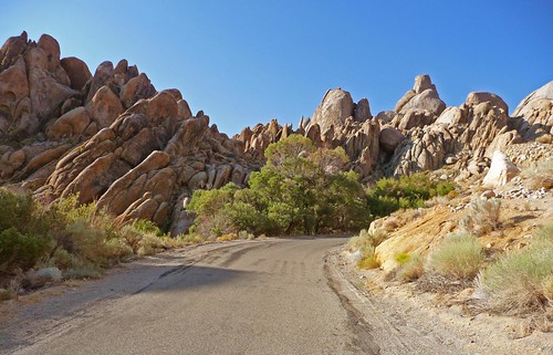
 Alabama Hills, that is. (Image from Flickr) Above is a scene shot along Tuttle Creek Road, west of Lone Pine, California, one of my favorite drives anywhere. The landscape is simply surreal.
The reason this comes up is that there's a nice travel piece today from the NYT on exploring the Owens Valley. Yeah, there's the typical "let's find the most upscale eateries and coffee shops in the region" stuff I expect from these pieces, but there are some nice descriptions (and a slide show) of natural and historical features as well. There's even a shout-out to the Tuttle Creek Campground- a very nice one for when higher elevations are closed by snow- two or three miles up from where the photo above was taken. One location discussed, Manzanar, a WW II Japanese internment camp, is something I've always wanted to stop at, but never taken the time to do so.
Of course, the author missed the single thing in Lone Pine that I would consider most "must-see:" the scarp west of town. Often described as the result of the 1872 earthquake, there was an article in either the GSA Bull. or in Geology claiming that, on the basis of rock varnish, the escarpment was the result of multiple quakes.
 To find the site I'm most fond of, take Whitney Portal road (it's well marked as you drive through town), and cross the LA aqueduct. Shortly afterward, there's a pullout-rest stop-parking area sort of thing. Note that in the embedded map, it's the paved loop beyond (west of) the much lighter unpaved road. (I think the gravel road is LADWP property, and gated) Park there, then walk north around the hill and onto the alluvial fan.
View Larger Map Because this stupid thing didn't embed, even though it shows up in the preview window.
As you round the hill, cut diagonally to the northeast. You can't miss it. I may not have the exact spot labeled with precision, but there's a linear feature that I'm pretty sure is the scarp (hence the '?').
 Note also that Tuttle Creek Road turns south off Whitney Portal just before the aqueduct. It's a relatively short loop drive up that road to Horseshoe Meadows Road, then back to Whitney Portal. Of course, if time limitations are not in place, there's years worth of stuff to see in the area. I'm reminded of another state-named song: Almost Heaven...
No comments:
Post a Comment